Don Silcock Samples the Breathtaking Scuba Diving of Timor Leste

On the 20th May 2002, a new country was born to the north of Australia. It was a very painful experience for its people, but one they had fought long and hard for, earning the respect of even those who had opposed its separation from Indonesia.
The country, Timor Leste, emerged from centuries of foreign rule – 455 years as a colony of Portugal and then 24 years under Indonesia after it was “annexed” by its much larger neighbour.

in what is a long and sorry tale of colonial exploitation followed by brutal Cold War “realpolitik” Timor Leste arrived in the world in a pretty sorry state. With the land stripped of its rich and highly prized sandalwood and its infrastructure destroyed by the departing Indonesians.
But it was free and independent at last… and in the 18 years since then, Timor Leste has done its best to moved forward and start to realise its full potential. With scuba diving seen as a key component of a sustainable tourism industry the country wants so much to develop!

So, What’s Special about Timor Leste?
A quick look at the map, combined with a basic understanding of the phenomenal force of nature that marine scientists call the “Indonesian Throughflow” (see Sidebar), is enough to tell you that the northern coast of Timor Leste holds considerable promise!
To the north of Timor Leste are Alor and Wetar, the most easterly of the chain of islands called the Lesser Sundas, which form the southern boundary of the huge Indonesian archipelago.

Further north still are the deep basins of the Banda Sea, layered with the rich phosphorus & nitrogen laden detritus of the sea. And, as the mighty Throughflow surges south towards the shallower waters of the Lesser Sundas, it creates upwellings that suck up those nutrients from the depths below.
Between Alor, Wetar and Timor Leste is the Ombai Strait, one of the three main passages through the Lesser Sunda islands and those nutritive-dense waters create and sustain the incredible biodiversity of that area.

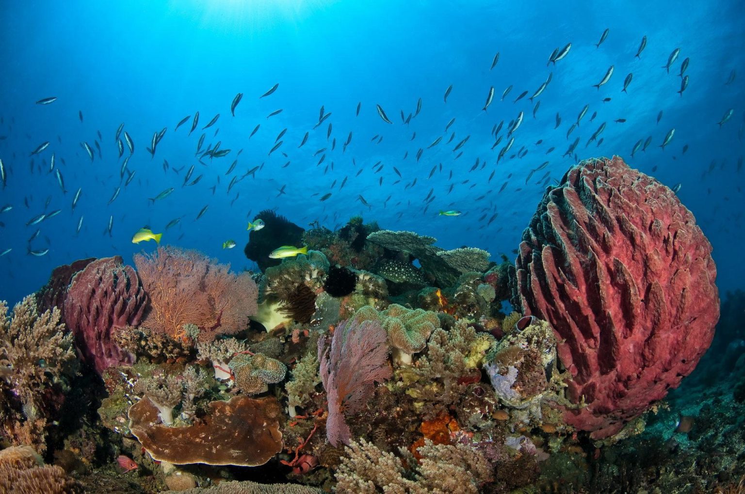
Scuba Diving Timor Leste
Timor Leste’s diving locations can be broken down into three main areas, consisting of those in and around the capital Dili, the coastal locations up to 2 hours’ drive to the east and west of Dili and the large island of Atauro to the north of Dili.
Dili
There are three sites that are dived regularly in Dili – the Pertamina Jetty near the center of the city, Tasi Tolu on the western outskirts and nearby Dili Rock.
All are shore dives and both Pertamina Jetty and Tasi Tolu are muck/critter sites, while Dili Rock is a mixture of critters and coral gardens.

Tasi Tolu takes its name from the three fresh water lakes below the nearby foothills and is a flat patch of marine growth in about 15m of water just off the beach. It would be very easy to miss, or simply ignore, that patch if you were not guided and that would mean missing out on the wide variety of resident photogenic critters!
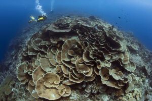
Dili Rock on the other hand is a much prettier site and its coral gardens are a delight to photograph, but you won’t find exotic critters there…
While Pertamina Jetty is the wreck dive you do when there isn’t an actual wreck… As the name suggests it is the jetty used to import fuels and refined products from the Indonesian national oil company Pertamina.

It can only be dived when there are no tankers moored there, but it’s an interesting dive and has a lot to see and photograph.
East of Dili
There are numerous dives sites heading east from Dili, all of which are shore dives reached by short paths from the main road and involve getting kitted up under whatever shade is available and then walking down the beach.
All the sites have sheltered entries, so actually getting in to the water is easy and exposure to the strong currents of the Ombai Strait is gradual and manageable.

My personal favorites to the east of Dili were Secret Garden, Marble Rock and One Tree – with Secret Garden standing out because its small, but superb, sponge garden with its resident colonies of photogenic purple anthias and silvery glass fish.
West of Dili
There are two main dive site areas to the west of Dili – Bubble Beach and the picturesque town of Maubara.
Bubble Beach is reputed to be one of the best dives in Timor Leste, but unfortunately access from the shore is not possible anymore as the area had been fenced off because the “bubbles” are believed to be natural gas leaking up from the deep water gas reserves that hold the key to Timor Leste’s future prosperity.
The fenced off area is the site of a proposed gas processing facility…

There are two sites at Maubara – the Church and the Fort, with the former offering some superb diving around the numerous bommies on the sloping coral slope. First impressions should be ignored though, because the shallower parts of the slope are not particularly appealing.
But as you go deeper at around 15m they come to life and positively abound with marine life that is nourished by the strong currents that sweep the site.
My favorite bommie was about 200m to the north-west of the main entry point straight down from the car parking area near the church. It is at around 19m in depth and was simply teeming with life.

Ataúro: The large and visibly stunning island of Ataúro lays 30 km due north of Dili and suits right in the path of the Indonesian Throughflow as it flows into the Ombai Strait.
The area has a reputation as a “marine mammal superhighway” because of the regular sightings of pelagics, dolphins and numerous whales including the mighty blue whale and the incredible sperm whale!
While the sightings are very real, encounters with those creatures are unlikely near the island while on scuba… A dedicated trip with a fast boat to get in position ahead of the migrating animals would be needed and the encounters would be on snorkel at, or near the surface – something I am hoping to do later this year…

Ataúro suffers from a lack of rainfall, which means that life is hard for the permanent residents of the island and development is significantly slower than on the mainland. But the lack of run-off from the island means that the visibility around Ataúro is exceptional.
The diving at Ataúro is concentrated along the west and east coasts of the island, with the west’s defining feature being its dramatic steep walls that descend in to the depths of the Ombai Strait. While the east coast is more scenic, fringing reefs that slope down gently.
The Indonesian Throughflow
The incredible flow of water known as the Indonesian Throughflow is caused by the significant difference in sea-level between the Pacific Ocean to the north-east of the archipelago and the Indian Ocean to the south-west.

The massive disparity is created by the trade winds and associated oceanic currents, which act in opposite directions in the northern and southern hemispheres. But the overall result is the largest movement of water on the planet which flows through the Indonesian archipelago.
So huge is the volume of water associated with the Throughflow that traditional measurements such as cubic meters & gallons are inadequate to describe it in an easily understandable way. So, the Norwegian scientist Harald Sverdrup invented the Sverdrup – one million cubic meters of water per second.
The best way to visualize a Sverdrup is to think of a river 100m wide, 10m deep and flowing at 4 knots, then imagine 500 of those rivers all combined together and that is one Sverdrup!
It is estimated that the total amount of seawater that passes through the Indonesian Throughflow is 20-22 Sverdrups, or 10,000 of those rivers.

Timor Leste, what’s in a name?
Timor Leste, East Timor or Timór Lorosa'e… Geographically the country is located in the eastern half of the island of Timor – the western half is very much part of Indonesia.
Officially the country is Timor Leste – a name derived from timur, the word for “east” in Bahasa Indonesia, while in Portuguese Leste is also “east”, so Timor Leste means “East East”
East Timor also means “East East” while Timór Lorosa'e is the Tetum (the language of the island of Timor) version of “East East”…

Summary for Scuba Divers
As divers we tend to be constantly looking for new and exciting places to try and Timor Leste offers an interesting mix of things to see both above and below the water.
Like they say I the real estate business – location, location, location… and Timor Leste’s location is perfect!
Very much in the mode of a developing country, Timor Leste’s rough edges add to its charm and the sheer determination of its people to overcome the country’s colonial past and the brutal years of the Indonesian occupation are simply admirable.
If you do decide to go, do yourself a favour and allow some extra time to do some land-based exploring and enjoy the country as it is now because it won’t stay like that forever!
Don Silcock
In more normal times Don is based from Bali in Indonesia, but is currently hunkered down in Sydney… His website: indopacific images has extensive location guides, articles and images on some of the best diving locations in the Indo-Pacific region and “big animal” experiences globally.
Photo Credit: Don Silcock
Want to read about more great places to dive?